
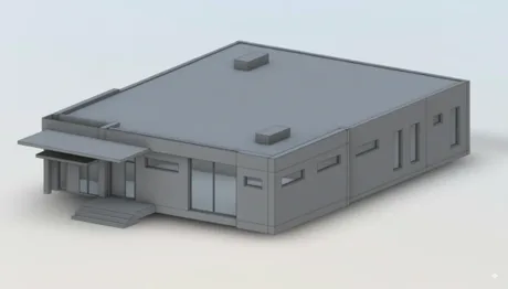
BIM Modeling
Information models (BIM) from 360° scanning of interior spaces. Measured Revit models and CAD drawings of existing spaces, ready for your design software.
Precise Information Models of Existing Spaces
We produce information models (BIM) of buildings and spaces from 360° scanning of interior spaces. The same scan that produces an interactive virtual tour also captures precise measurements — from which we model structures, openings, and spaces into an information model. An up-to-date, measured model of an existing site as a basis for renovation, alteration, and design.
We model existing sites only — buildings that can be measured on site. The model is based on measured reality, not on a design. We do not produce design models for new construction under the Finnish Building Act.
Benefits of the Service
A Model Based on Measured Reality. Produced from a precise scan, not old drawings. Measurement accuracy is typically ±1 cm from camera to wall surface.
Ready for Your Design Software. The model is delivered in Revit format (.rvt) and the drawings in DWG, DXF, and PDF. We can also deliver the model in IFC on request. Tell us at the ordering stage which software you use, and we will make sure the file opens correctly at your end.
Accurate Enough to Design From. The model contains walls, doors, windows, and spaces following measured positions and room dimensions. In industry terms this is LOD200: the geometry is correct, but the model carries no structural or building services data. Wall thicknesses are drawn to standard dimensions, since you cannot see inside a wall. Design solutions and actual structural thicknesses are added by the project's designer.
The Model in the Right Place. We measure the building's corner points with an RTK GNSS rover and georeference the model accordingly. The model is delivered in the project's plane coordinate system — typically the municipality's ETRS-GKn zone — and the N2000 height system. The Revit and CAD data therefore opens directly in the correct location. If you need the IFC file georeferenced, we verify that separately before delivery.
One Visit, Multiple Deliverables. A single scan produces an information model, floor plans, and a virtual tour.
What BIM Modeling Is Used For
- Baseline data for renovation and alteration design
- As-built information model of an existing building
- Documentation of spaces and structures for maintenance
- Floor plans and CAD data as a basis for design
What We Deliver
- Information model — Revit (.rvt), walls, doors, windows, and spaces at measured positions. IFC on request
- CAD drawings — floor plans with dimensions and areas (DWG, DXF, PDF). Dimensioned drawings, reflected ceiling plans, exterior elevations, and roof plans available as add-ons
- Laser point data — laser measurement points per floor, for checking the drawings (DXF)
- Georeferencing — model in the project's coordinate system (ETRS-GKn) and N2000 height system
Part of a Bigger Picture
Information models are produced from the same 360° scan that also produces the virtual tour. Visual surface models of exteriors are produced with drone photogrammetry — see 3D models. To compare an existing model to the as-built structure, use BIM verification.
Frequently Asked Questions
What is the information model produced from? From 360° scanning of interior spaces, combining 360° photography with precise laser measurement.
In which formats do you deliver the models? The information model is delivered in Revit format (.rvt) and the drawings in DWG, DXF, and PDF. We can also deliver the model in IFC on request. We check the files before delivery and will tell you in advance if any software needs special handling.
What's the difference between an information model and a drone 3D model? A BIM information model is structure-based with data, from interior scanning. A 3D model from drone photogrammetry is a visual surface model — useful for as-built comparisons.
How accurate are the models? Measurement accuracy is typically ±1 cm on wall measurements. In practice that means room dimensions and opening positions are reliable as design baseline data. Exact figures and measurement conditions are set out in a technical annex we send on request.
Can the areas be used as official floor area? Not directly. The scanning system calculates areas to an international standard that differs from the Finnish method for calculating dwelling area (SFS 5139). Individual room dimensions are usable as they are, but official floor area is calculated separately from the drawings. Tell us in advance and we will agree how to handle it.
What is the laser point data? The points recorded by the laser measurement are delivered per floor as a DXF file, which lets you verify the drawing dimensions afterwards. It is not a three-dimensional point cloud from laser scanning, so if your project needs one, tell us in advance and we will point you to the right service.
Do the wall thicknesses reflect reality? Room dimensions and opening positions are based on measurement. Wall thicknesses are drawn to standard dimensions, since you cannot see inside a wall. If you need actual structural thicknesses, these are established through structural openings or from old structural drawings.
Do you produce design models for new construction under the Building Act? No. The design model for a building permit has its own requirements (Ministry of the Environment decree 1340/2025) and is always prepared by the project's building designer, who is also responsible for its correctness. We supply the measured baseline data that designer works from.
In which coordinate system is the model delivered? In the project's own plane coordinate system — in practice the municipality's ETRS-GKn zone — and the N2000 height system. Positioning is based on building corner points measured with an RTK GNSS rover.