Case: Volume calculation of material piles with a drone - Over 51,000 m³ in a recycling area
15 Dec

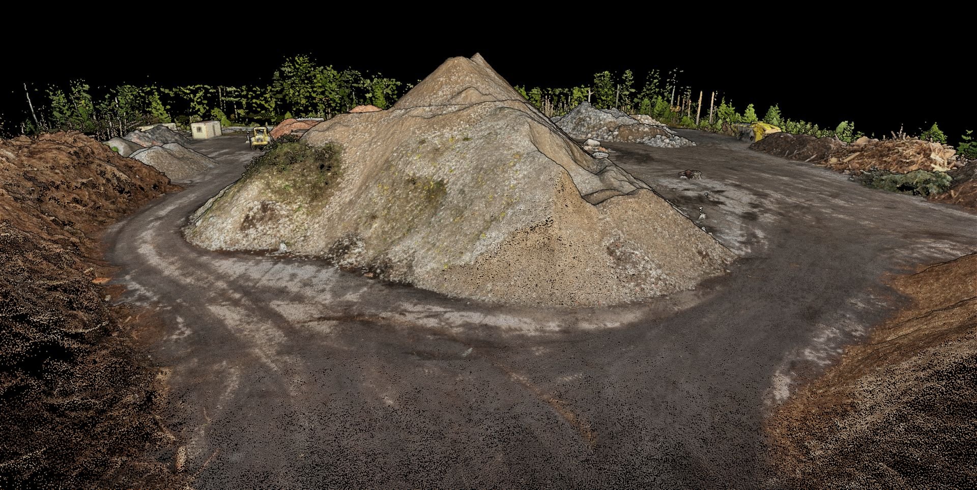
How do you accurately measure the volume of 21 different stockpiles at a recycling facility? Traditional measurement methods quickly run into practical limitations when stockpiles range from 40 m³ to nearly 20,000 m³ and materials vary from wood chips to crushed rock. Drone imaging and photogrammetry offer an efficient, accurate, and safe solution.
The Challenge: Annual Inventory of 21 Stockpiles
Recycling and waste management facilities have an ongoing need for accurate material quantity data. Inventory is a critical part of operational planning, financial reporting, and customer order management. In this project, the task was to conduct an annual inventory of 21 stockpiles with a combined volume exceeding 51,000 cubic metres.
The materials were highly diverse – from wood-based materials such as brush and wood chips to various construction material aggregates: crushed concrete, crushed rock, crushed asphalt, and crushed brick. The stockpiles varied greatly in size, with the smallest at approximately 42 m³ and the largest at nearly 19,100 m³.
Limitations of Traditional Measurement Methods
Determining stockpile volumes using traditional methods is challenging and often inaccurate.
RTK GNSS Measurement on Stockpiles
Real-Time Kinematic GNSS measurement (RTK) is an accurate method for many applications, but it encounters practical problems with stockpiles:
Safety risks: The surveyor must climb high stockpiles, which can be dangerous especially on loose or unstable materials such as wood chip piles or stumps
Uneven surfaces: Stockpiles are often irregularly shaped with broken surfaces, making it difficult to create a uniform measurement grid
Time-consuming: Measuring 21 stockpiles individually would take many hours
Limited number of points: In practice, only a limited number of points can be measured, reducing the accuracy of volume calculations
Estimation and Computational Methods
Traditionally, stockpile volumes have been estimated visually or with simple geometric calculations. These methods are:
Highly inaccurate, with error margins of 20–30% or more
Subjective and dependent on the operator's experience
Unable to produce documentable and verifiable results
The Solution: Drone Imaging and Photogrammetry
Drone-based photogrammetry offers a modern solution for stockpile volume calculation. The method combines accuracy, efficiency, and safety.
How Does Photogrammetry Work?
Photogrammetry is a technique that creates an accurate three-dimensional model of an object by analysing the geometry of multiple overlapping images. The process consists of the following steps:
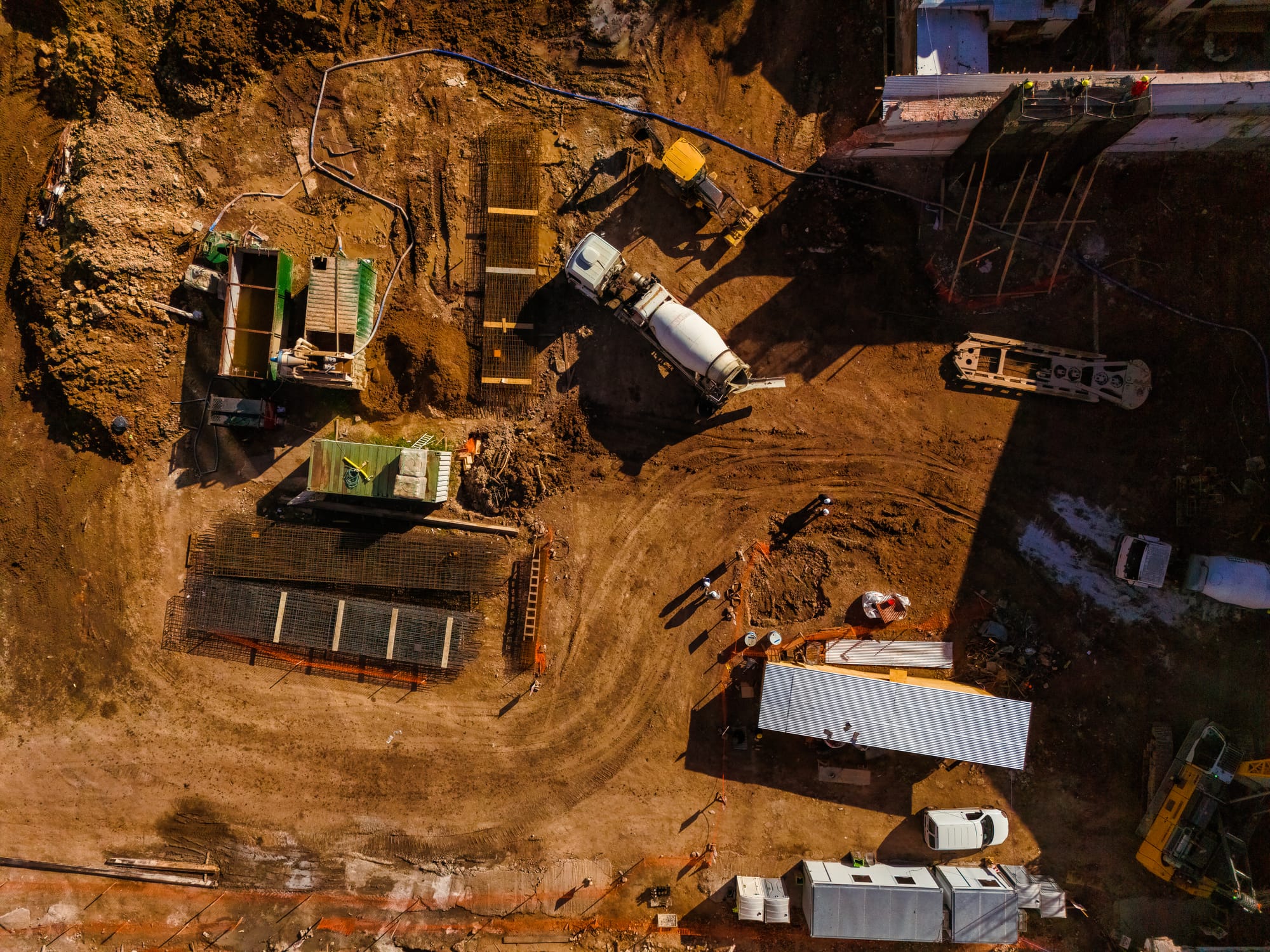
Flight mission: The drone flies a pre-planned route, capturing hundreds of images of the area. Image overlap is typically 70–80% in both directions.
Georeferencing: RTK/PPK GPS technology enables centimetre-level accuracy for image positioning. Ground checkpoints are also used for result validation.
Feature matching: Photogrammetry software automatically identifies the same features across different images and calculates their 3D positions.
3D model creation: The software generates a detailed three-dimensional surface model (3D mesh) of the entire area.
Volume calculation: Once the base level of the stockpile and the 3D geometry of the surface are known, the volume can be calculated automatically with high accuracy.
Project Execution
The recycling facility inventory project covered 21 stockpiles with a total volume of 51,448.2 m³. All stockpiles were documented during a single flight mission, demonstrating the efficiency of the method.
Technical Accuracy and Reliability
The accuracy of photogrammetric measurement depends on several factors: flight altitude, camera quality, image overlap, georeferencing method, and surface characteristics of the subject.
Centimetre-Level Positional Accuracy
The combination of RTK/PPK GPS technology and ground checkpoints enables centimetre-level positional accuracy for the 3D model. This means that every point in the model typically has a positional accuracy of 1–3 cm.
Volume Accuracy for Different Materials
Volume calculation accuracy varies slightly by material type.
Dense Aggregates and Construction Materials
Crushed concrete, crushed rock, crushed asphalt, and crushed brick form dense, well-defined surfaces. For these materials, volume accuracy is typically ±1–2%. This is significantly more accurate than any traditional measurement method.
Loose Wood-Based Materials
Brush, wood chips, stumps, and other wood-based materials are airy and irregular in structure. Photogrammetry accurately measures the surface geometry, which includes the air gaps between materials. This is precisely the information the client needs – the physical space occupied by the stockpile. When materials are sold or moved, this "bulk volume" is the practically relevant metric.
Compared to estimation or computational methods, photogrammetric measurement provides a repeatable, objective, and documented result with clearly defined accuracy.
Key Practical Benefits
1. Feasibility
Drone-based measurement makes possible what would be extremely difficult or practically impossible with traditional methods. A comprehensive, accurate measurement of 21 stockpiles can be completed in a single day without workers needing to climb on the piles.
2. Safety
Workplace safety improves significantly when surveyors do not need to climb stockpiles. Loose wood chip piles and tall solid stockpiles in particular can be hazardous to climb.
3. Efficiency
A single flight mission provides comprehensive documentation of the entire area. With traditional measurement methods, the same work would take several days and require multiple workers.
4. Comprehensive Documentation
In addition to volume figures, the following deliverables are produced:
3D models: Each stockpile can be viewed as a three-dimensional model, with distances and elevation differences measured
Orthomosaic image: An accurate, geometrically corrected aerial image of the entire area, serving as visual documentation and aiding material identification
Reference data: When repeated annually, the measurements produce comparable data showing material flows and inventory changes
Reports: Detailed volume reports that can be integrated into the company's inventory management and reporting systems
5. Accuracy and Reliability
Centimetre-level positional accuracy and 1–2% volume accuracy for dense materials clearly surpasses the accuracy of traditional methods. This supports financial reporting, inventory management, and delivery planning.
Deliverables
Upon project completion, the client receives:
Volume report: An Excel or PDF report showing the volume, material, and location of each stockpile
3D models: A 3D surface model of the entire area as well as individual stockpile models, viewable via web browser or specialised software
Orthomosaic image: A high-resolution, geometrically accurate aerial image of the entire area in GeoTIFF format
Raw data: If needed, the images and processed point cloud for the client's own use
Who Is This Service For?
Drone-based stockpile volume measurement is a valuable solution for many industries:
Recycling and Waste Management Facilities
Annual or regular inventory ensures accurate stock tracking and supports financial reporting. Monitoring material quantities helps optimise inventory levels and space utilisation.
Construction Material Suppliers
Accurate information on aggregate, sand, gravel, and other construction material inventory levels enables reliable delivery assurance and efficient order management.
Construction Sites
In earthmoving works, tracking the volumes of soil materials and deposited materials throughout the project. Documentation can also support contract calculations and auditing.
Mines and Quarries
Monitoring product and waste stockpiles, documenting production volumes, and reporting.
Forest Industry
Measuring volumes of wood chip, bark, sawdust, and other wood-based product stockpiles at reception areas and storage facilities.
Summary
This case study demonstrates how drone-based photogrammetry solves a practical challenge where traditional methods are neither efficient nor even feasible. When 21 diverse stockpiles – with a combined volume exceeding 51,000 cubic metres – needed to be accurately inventoried, drone imaging was simply the logical solution.
The key advantages of the method are clear: centimetre-level measurement accuracy, safe execution without climbing on stockpiles, a fast process completed in a single flight mission, and comprehensive documentation that delivers value year after year.
For recycling and waste management facilities, construction material suppliers, and construction sites, drone-based volume measurement is an investment that pays for itself through better inventory management, more reliable reporting, and more efficient operations.
Interested?
Droneca provides professional drone services for material volume measurement and other surveying needs in Finland. We help companies leverage the opportunities offered by drone imaging and photogrammetry in practical business operations.
Contact us for a tailored quote for your project or book a free demo where we show you how the service works in practice.
Case: Volume calculation of material piles with a drone - Over 51,000 m³ in a recycling area
Construction Site Documentation with Drones: Why Regular Monitoring Saves Time and Money

What Buyers Need to Know About Drone Operator Certification in Finland

Local development in Ostrobothnia: Leader support for Droneca Oy