CONSTRUCTION SITE SURVEY
Know where your project stands — week after week, with centimetre accuracy
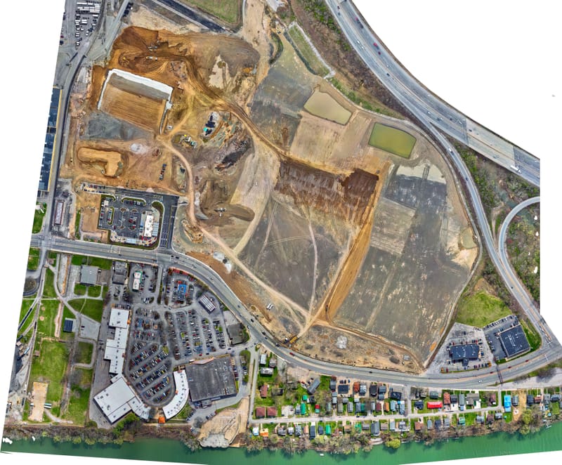
Construction site mapping with drones gives you precise, up-to-date data on the entire work site — without disrupting operations on the ground. Using RTK/GNSS technology, we achieve centimetre-level accuracy, and results are delivered as orthophotos, elevation models and volume measurements ready to use in your project.
What's included in construction site mapping?
- RTK/GNSS positioning — centimetre accuracy without ground control points
- Orthophotos — geometrically corrected aerial images for precise surface mapping
- Elevation models (DSM/DTM) — detailed terrain models for planning and monitoring
- Volume calculations — excavated, fill and stockpile volumes measured from the air
- Photogrammetry — 3D point clouds and textured models of the work site
- Weekly or monthly reports — regular progress monitoring for the project
Why choose drone mapping for your construction site?
Traditional surveying takes time and requires personnel on site. Drone mapping covers the entire work site in a matter of hours, without stopping operations. You get a complete, measurable picture of the situation — every week if needed.
- Save time compared to traditional surveying
- Identify problems before they escalate
- Document progress for the client and management
- Data for billing and volume tracking
How the process works
- Contact and planning — we assess your needs and plan the flight mission
- Site flight — safe and efficient mapping with RTK drone
- Data processing — photogrammetry, elevation models and volume calculations
- Delivery — orthophotos, models and reports in your preferred format
Book a construction site mapping
Contact us to discuss your project — we'll deliver a quote within 24 hours.